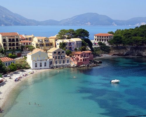
The mysteries of Kefalonia island
The Islands Phenomena
Between 65-100 million years ago, a mixture of chalk and limestone formed the body of the island. ‘Karst’ formations were formed these are created by underground waters which have eroded the limestone rock, resulting in passages and cavities on the earth’s surface and a vast underground water network. In some areas, they are fed by underground rivers, consisting mainly of rainwater from the mountains and others formed by seawater. The passage of seawater is the start of one of the geological phenomenon’s of the island known as the ‘ Kefalonian Water Mystery’
“White bridal dresses stunning and pure, bringing promises, binding two souls together, life forces connected, holding the same vision..” ― Jennifer Lynch
Previous image
Next image
KATAVOTHRES
At the tip of the Lassi peninsula, the famous phenomena of Katavothres is situated. 3 km outside of the island’s capital Argostoli in the area of Fanari. At first, it was observed that the water from the sea went into the ground through holes only then to disappear. In the early 20th century, there was a hydroelectric plant and ice factory, which made use of the force of this water. Since then many experts have given their varying theories.
However, it wasn’t until 1959 that speleologist Yiannis Petroeilos and the Austrian geologists Maurin and Zolt began to systematically research the area.
On 26th February 1963, 140 kilos of ‘ouranini’ a water-soluble dye was poured into the fissures at Katavothres. It was discovered that the water underwent a journey through underground rivers and streams, and on 12th March 1963 just 14 days later traces of the ‘ouranini’ appeared in the springs around the village of Karavomilos by the old watermill and lake of the same name, close to Sami. Some 15 km away dye was also found to a lesser degree in the spring of Fridi and Ayia Efimia.
It wasn’t until 1989 that the most recent theory was put forward by a Frenchman named Drogue. He suggests that three things are responsible for the strange movement of water.
1. The existence of the ‘Karst fissures’.
2. The simultaneous effect of the difference in sea levels between the 2 sides of the
island.
3. The difference in density between the saltwater and the semi saltwater.
Today the validity of these findings has been verified by the use of radioisotopes.
Another strange thing is that the stalactites that remain in the caves of the island lean noticeably to one side. This is characteristic in areas where earthquakes are renowned. However, despite the many earthquakes that occur on Kefalonia, no alteration has been observed that has changed the phenomenon of the seawater vanishing into the earth at Katavothres and re-emerging into the sea at Karavomilos.
KARAVOMILOS
After the above investigations conducted 1963, it was discovered that the water, which disappears at Katavothres, flows into the village of Karavomilos by underground rivers after 14 days. The water appears in and around the sea and the small saltwater lake which has been created there.
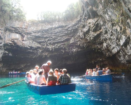
THE CAVE OF MELISSANI
The collapsed cavern and underground lake of Melissani, 2 kilometers outside Sami, is one of the most significant sights on the island. Situated near the lake of Karavomilos, Melissani lake is one of the most idyllic places which was well hidden from mankind for many years. Excavations made by speleologist Yiannis Petroeilos in 1951 have shown Melissani belonged to the early Hellenistic period. Later in 1963 archeologist, Mr. S. Marinatos began excavating in the area. These excavations brought to light artifacts of the nymph Melissanthi, a statuette, and an earthen tray with a depiction of Pan along with the first find of 1951 an ancient lamp, all which are now on display in the Archaeological Museum of Argostoli.
Some believe it has taken its name from the nymph Melissanthi. Others think the name came from the beehives or ‘Milissia’ in Greek, which have existed in the area since ancient times. The cave lent itself to worshippers of Pan and the Nymphs.
Worshippers would not venture into the depth of the cave, probably because they were afraid of the gods, albeit they must have climbed down ropes from the roof, in order to bring their offering to the god Pan. They lit a great fire and chanted in an attempt to coax the divine powers to fulfill their desires. Even the stalactites were worshipped. Their shapes often inspired their names which in turn gave the cave its name The temple of the Nymphs.
The cave is 40 meters in width, 36 meters in height, and 3.5 meters in length. Inside, it is covered by water 20 to 30 meters in depth due to the collapse of a part of the roof. Small rowing boats carry visitors around the lake to admire the spectacular sight of the stalactites and the changing colors of the water. The water is ice cold 150 C all year long with only eels living in its depths. Pigeons and bats being the only thing to disturb the peace and tranquility this wonderful sight holds.
DROGARATI CAVE
Drogarati cave stands about 4 km outside of Sami town near the village of Haliotata. The cave is estimated to be around 150 million years old. A circular staircase leads to the entrance of the cave, which opens to a broad flat space and the right-hand corridor takes you to the Royal Balcony. It’s remarkable for its unique red stalagmites. It is 45 meters in width, 21 meters in-depth, and 65 meters in length. It consists of two parts. The upper part has collapsed and only huge stalactites of different colors remain, which when lit create a multi-colored picture of unique beauty.
The second part is the cave proper (65 x 45 m), which is accessible to tourists, has a purpose-built platform which is the stage for many cultural events and concerts because the acoustics are some of the finest in the world, its name is ‘The Hall of Apotheosis’. Visiting dignitaries are seated on the ‘Royal Balcony’, which offers a spectacular view from the top of the cave. The musicians are seated on the opposite side on the podium along the cavity of a rock, higher up among the stalagmites. The cave can accommodate up to 500 people
AVITHOS LAKE
This very small lake is situated on the East side of the island between Poros and Sami on the outskirts of Ayios Nikolaos village. There is a small narrow road signposted to Avithos Lake. Follow the road until you come to a small parking area under some trees. The lake can be found to the left hidden amongst the rushes. The name Avithos or Megali Akoli comes from the islanders’ belief that the lake was bottomless. The abundant water actually comes from a number of freshwater springs that irrigates the surrounding area.
KOUNOPETRA
‘Kounopetra’ meaning swaying rock is situated approximately 10 km south of Lixouri on the picturesque cape of Akrotiri, 5 km beyond the village of Manzavinata. This was once another significant geological phenomenon. A large slab of the coastal rock before the earthquake in 1953, used to oscillate back and forth with the sway of the sea, with constant and rhythmical movement. After the earthquakes of 1953, the rock’s base was stabilized.
VIRGIN MARY AND THE SNAKES
Markopoulo is internationally known for a unique phenomenon that coincides with festivities in honor of the Virgin Mary and Child Panayia’ on August 15th. The original church of Panayia of Langouvarda was burned in the war during 1945 and its remains destroyed in the earthquake of 1953. A small number of small harmless snakes appear around the church and especially the old bell tower. The snakes are said to have a mark in the shape of a cross on their heads. Locals see them as a sign of good luck and consider them as sacred.
The church is visited by hundreds of people on this day each year, to witness the event for themselves. Despite this surge on the small church, the real story belongs to the village of Arginia. The old church which no longer exists in the village of Argonia was first established as a nunnery. When the nunnery was attacked by pirates in 1705, the nuns prayed to the Virgin Mary to be transformed into snakes in the eyes of the advancing pirates to avoid being taken.
Their prayers were answered and the miracle took place. The pirates were frightened away when they entered the monastery to see through their eyes only that the floor, walls, and icons were covered with snakes. Since then, the snakes ‘return’ on this day to the village and can be found in the rubble of the church from the 6th of August. It is said that the snakes fail to appear only when the island is in distress, as they did during the German occupation of the island and the earthquakes of 1953. The snakes follow a migratory and mating path from the village of Arginia following a watercourse down to Markopoulo.
OATS WITH SILVER TEETH
In the region of Mount Dynati. Goats with silver teeth can be found, the silver teeth are believed to be the result of a mineral ‘mica’ that stains the animals’ mouths. A herb also grows on the mountain which helps with the animals’ digestion, this is probably the true reason for the phenomenon.
The 1953 Earthquake
From the 9th August 1953 to the 14th August 1953 The Ionian islands of Kefalonia, Ithaka, Lefkada, and Zakynthos suffered tremors reaching as high as 7.3 on the Richter scale. The worst of these was on the 12th August when a devastating earthquake was responsible for the loss of life, injury and the destruction of most of the islands old Venetian buildings and ancient treasures.
The soul-destroying earthquake of 1953 that was responsible for laying most of the island to waste, measured 7.3 on the Richter scale. A scale that measures between 0 to 8. Each point was 100 times more powerful than the previous. The islands very foundation was shaken by the 113 tremors that preceded the mainshock.
The damage was appalling, in Kefalonia, only sparing only a few areas, but not without leaving horrendous scars. Entire towns and villages were razed to the ground. Hundreds were made homeless, the streets choked with rubble, and huge gaps broke the earth. This was the time when many desperate Kefalonians left their homeland to seek a better life abroad, with many leaving for America, Australia, South Africa, Germany, and Great Britain. Before the earthquake of 1953, Kefalonia had 365 villages. Today only 200 of them remain most located mainly near the coast with a few scattered on the plains and hillsides all today connected by a network of main, secondary and dirt roads.
The buildings were reconstructed quickly, and the incident brought worldwide support, with aid from countries such as France, Great Britain, Sweden, Norway, and the United States. The houses were re-build simply and quickly with little and no time spent on aesthetics, most in the outlying areas were built from wood and the remains of the destroyed buildings, whilst others in the towns were constructed from concrete and in the sixties style of box bungalows.
These are slow today, beginning to disappear, making way for the new and stronger structures all built with strict anti-seismic specifications, to withstand a tremor of 8 on the Richter scale. However, some of the original buildings did survive and these can be seen in the North of the island, the best examples being in Fiskardo. With the older structures still standing in Assos and many other villages along the main road or hidden within the island’s greenery.
Today you will find the use of bright pastel colors to finish off the exteriors of buildings and the new constructions, with many features such as decorative balconies, archways and external staircases added to enhance and bring back the look of a bygone era.
Kefalonia weather
If you are looking for airline tickets and flights to Kefalonia enter the dates of arrival and departure in the left box, and the online reservation program will show you suggestions and prices for your flight where you can make your reservation directly and securely.